
Noise Mapping
A noise mapping study is a detailed analysis of the noise levels in a specific area. It involves the use of sound sensors, computer modeling or software and data analysis to create a detailed illustration of noise levels in the area of study.
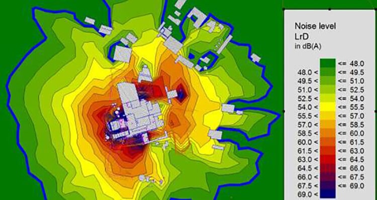
Noise contour mapping are simply colored map to indicate intensity of noise on the map of place of study conducted. It is very helpful to identify area where noise levels exceed recommended threshold.
What is meant by Noise Mapping?
Let’s understand it in detail. Noise mapping is method of collecting noise level data using noise monitoring sensors, data modelling and visualizing in graphical manner. The purpose of this process is to get detailed map of noise levels that can highlight areas where noise levels are exceeded so that measures can be taken to reduce noise.
Why is Noise Mapping Important?
Noise pollution has become a growing concern in urban and industrial areas, affecting both human health and environmental quality. Prolonged exposure to high noise levels can lead to hearing loss, stress, sleep disturbances, and reduced productivity. Noise mapping helps identify noise pollution hotspots, enabling authorities and businesses to implement noise control measures. By visualizing noise levels, it becomes easier to enforce regulations, optimize urban planning, and improve the overall quality of life in residential and commercial areas.
Types of Noise Mapping
There are many types of Noise Mapping but most popular types are
- Strategic Noise Mapping: This type is used by government agencies and large corporates to measure noise reduction measures they have taken for big projects
- Environmental Noise Mapping: Environmental noise mapping is done by environmental Protection agencies to measure impact of noise on environment and wildlife.
- Community Noise mapping: In this type local communities are taken into consideration where noise pollution is at very high and to develop strategies reduce noise levels.
Industrial Noise Mapping
Industrial areas contribute significantly to noise pollution due to machinery, transportation, and production activities. Industrial noise mapping helps evaluate noise levels in factories, warehouses, and industrial zones. It also ensures compliance with regulatory limits and provides insights into noise control measures like sound barriers, insulation, and optimized work schedules.
Construction Noise Mapping
Construction projects often generate high-intensity noise, which can be disruptive to nearby residents and businesses. Noise mapping in construction sites helps monitor noise exposure levels, plan construction activities during permissible hours, and implement measures such as temporary noise barriers and low-noise equipment to minimize disturbances.
Noise Mapping Procedure
Noise Mapping Procedures can be divided in three types based on tools used i.e., Sound Sensors, Computer Simulation and Data Analysis.
Also read about Noise Level Monitoring Procedure
In Noise mapping procedure, Sound Sensors play very important role. Noise level monitoring Sensors are placed in strategic locations in the study area. Data is collected periodically from noise sensors and it is used to create detailed noise map which shows distribution of noise levels in study area.
Computer Modelling or Noise mapping software is another tool used in Noise Mapping procedure. In this method map is fed to the software and based on conditions it can generate and simulate noise patterns based on conditions. For e.g., if we create road or construction project in nearby area then noise level can increase for that area and then based on noise reduction techniques it can also shows which technique is impactful in those conditions.
Data Analysis is also a great tool for Noise Mapping. This Noise Mapping procedure involves analyzing large amount of data on noise level. And then after studying trends and patterns, high noise level areas and potential sources can be identified. This can help to take measures to reduce Noise levels and prioritize areas for action.
How Accurate is Noise Mapping?
Noise mapping accuracy depends on data collection methods, measurement frequency, and environmental factors. Modern GIS-based noise models and AI-powered analytics can enhance accuracy by predicting noise propagation under different scenarios. However, real-world validation through periodic noise monitoring ensures the noise maps remain reliable and up to date.
Learn more about Noise Level Monitoring and Testing
Noise Mapping Software
There are many noise mapping software are available in the market. Here are some of the popular ones:
- CadnaA: This is the popular among all. This has features to add virtual model of area and simulate noises in different conditions. This is widely preferred by researchers, government agencies etc.
- SoundPLAN: It allows to create detailed map and perform various analysis. This is popular in environmental consultants and government agencies
- IMMI: This is noise modelling software which can simulate noise level at airports, traffic and inplant noises, etc.
- NoiSee: This is good tool to create detailed noise map using data gathered from Noise sensors and computer models
- Norsonic Nor-Map: This has options for indoor and outdoor noise map.
- Odeon: This also has features like indoor and outdoor noise mapping. It can simulate noise mapping for complex terrain.
- AERMOD: A software can be used for air quality and noise quality modelling.
- INM: This is used by aviation authorities for airport noise mapping
- SOUNDRISK: A software can be used for environmental noise mapping for noise generated from transportation, industries and wind turbines, etc.
- SIMUL8 Noise: This is used to simulate noise mapping from sources like industrial facilities, construction sites and transportation, etc.
Free and Open-Source Noise Mapping Software
While premium software like CadnaA and SoundPLAN are widely used, several free and open-source tools are available for noise mapping:
- NoiseModelling – A GIS-based open-source tool for urban noise mapping.
- QGIS Plugins for Noise Mapping – Various plugins available within QGIS allow users to overlay noise data on geographic maps.
- Harmonoise – An EU-funded noise prediction model, useful for environmental noise analysis.
These tools provide an accessible starting point for small-scale projects, academic research, and community-driven noise mapping initiatives.
Traffic Noise Monitoring
Traffic noise monitoring is an essential aspect of urban planning and environmental management, aimed at understanding and mitigating the impact of road traffic on communities. It involves the systematic and continuous measurement of noise levels generated by vehicles on roads, highways, and other transportation routes.
By deploying specialized noise monitoring equipment and sensors strategically throughout urban areas, authorities can gather real-time data on traffic noise patterns and assess its effects on public health and overall quality of life.
Through traffic noise monitoring, city planners and policymakers gain valuable insights into noise pollution hotspots and peak hours of noise generation, enabling them to develop targeted interventions.
This data-driven approach empowers decision-makers to implement effective measures such as traffic management strategies, sound barriers, and urban design improvements to reduce noise levels and create more livable environments for residents.
Additionally, traffic noise monitoring plays a crucial role in adhering to regulatory standards and guidelines set by environmental agencies. By tracking noise emissions and comparing them against permissible limits, local governments can ensure compliance and take timely actions to address any potential violations.
Health Impacts of Traffic Noise Pollution
Studies show that prolonged exposure to road traffic noise above 55 dB can increase the risk of hypertension, sleep disorders, and cardiovascular diseases. Traffic noise can also reduce cognitive performance in children and increase stress levels among residents. By using noise mapping, policymakers can design effective noise reduction measures, such as low-noise road surfaces, optimized traffic flow, and soundproofing strategies in high-noise areas.
Ultimately, the process of traffic noise monitoring fosters sustainable and people-centric urban planning, contributing to healthier and more harmonious communities where residents can enjoy the benefits of reduced noise pollution and improved overall well-being.
Benefits of Noise Mapping
The main benefit of Noise mapping is managing environmental Noise Pollution. This Procedure provides details understanding of noise levels in study area. It also helps in identifying sources of noise pollution and impacting area which helps in taking effective measure to reduce noise levels.
It can also help to take measures to reduce noise for environment and communities. Noise Map helps to identify areas where sound barriers can reduce noise levels and restriction on noisy activities in certain areas.
Regulatory Compliance and Legal Benefits
Noise mapping is essential for industries, construction sites, and urban planners to adhere to legal noise limits set by environmental agencies. Businesses that exceed noise regulations may face fines, operational restrictions, or legal challenges. A well-documented noise mapping study helps demonstrate compliance, reducing legal risks and ensuring smoother project approvals.
Smart City Applications and Future Trends
With the rise of smart cities, noise mapping is being integrated into real-time monitoring systems. IoT-powered sensors collect noise data continuously, allowing cities to respond dynamically to noise pollution. AI-driven analytics can predict future noise levels, helping urban planners make data-driven decisions for sustainable development.
in a conclusion, Noise Mapping is helping to take significant step towards creating a healthier and more sustainable environment.
A noise map serves as a valuable tool for understanding and managing noise pollution within a specific geographic area. By visually representing noise levels across neighborhoods, streets, and public spaces, noise maps help urban planners, policymakers, and environmental authorities make informed decisions. These maps assist in identifying noise hotspots, areas of concern, and noise-sensitive zones, facilitating the design of effective noise mitigation strategies.
Additionally, noise maps raise public awareness about the extent of noise pollution, encouraging community engagement and advocacy for quieter and healthier living environments. Overall, noise maps play a crucial role in shaping urban development, ensuring regulatory compliance, and fostering public participation in efforts to reduce noise pollution’s impact on quality of life.
Creating a noise map involves a systematic approach that integrates real-world noise measurements with geographic information system (GIS) technology. Initial data collection is conducted using sound level meters positioned across the target area to capture noise levels from various sources and at different times.
This collected data is then processed and analyzed to determine average noise levels and trends. Using GIS software, the noise measurements are mapped onto a digital representation of the area, often using contour lines or color gradients to visually depict noise levels. Interpolation techniques and noise propagation models may be applied to estimate noise levels between measurement points and account for factors like distance and barriers.
The resulting noise map provides a clear spatial overview of noise distribution, aiding urban planning, environmental assessment, and the implementation of noise abatement strategies. Regular updates and validation against real measurements help maintain the accuracy and relevance of the noise map over time.
Using AI and Machine Learning for Noise Mapping
Advancements in AI and machine learning are transforming noise mapping by predicting noise levels based on various factors such as traffic density, building structures, and weather conditions. AI algorithms analyze historical noise data and suggest optimal strategies for noise reduction, making noise mapping more efficient and cost-effective.
Noise contour mapping is created through a series of steps involving data collection, analysis, and visualization. First, noise measurements are taken at multiple points within the study area using sound level meters. The collected data is then processed to calculate average noise levels and identify patterns.
Using Geographic Information System (GIS) software, noise measurements are spatially plotted, and contour lines are drawn to connect points with similar noise levels. Interpolation techniques and noise propagation models can be applied to estimate noise levels between measurement points, resulting in a contour map that visually represents the distribution of noise intensity across the area.
The primary sources include traffic, industrial machinery, construction activities, railways, airports, and loudspeakers in urban areas.
Noise levels are affected by traffic density, road conditions, weather, building structures, and urban design.
Yes, indoor noise mapping helps identify sources of noise within buildings, such as HVAC systems, machinery, and room acoustics.
A noise mapping project includes data collection, noise modeling, GIS mapping, and analysis of results.
Most environmental guidelines recommend below 55 dB during the day and 45 dB at night in residential areas.
Noise maps should be updated every 3-5 years or after major infrastructure or traffic changes.
Common strategies include sound barriers, low-noise road surfaces, green spaces, better urban planning, and traffic management.
They help identify high-noise zones, allowing city planners to implement noise reduction measures like zoning laws and soundproofing.
Many countries require noise mapping under environmental laws, especially for airports, highways, and industrial areas.
Yes, AI and simulation models can predict how noise will change due to new developments, traffic growth, or urban expansion.
Excessive noise disrupts animal communication, breeding, and migration patterns, affecting biodiversity.
Industries like construction, transportation, manufacturing, urban planning, and environmental consulting use noise mapping for compliance and mitigation.
Yes, with smartphone apps and open-source noise mapping tools, communities can monitor and report noise pollution.
Governments use them for regulatory enforcement, city planning, and environmental impact assessments.
These are mathematical models that predict how noise spreads based on terrain, obstacles, and environmental factors.